ALGARVE WEST - MUST SEES

Cape Saint Vincent
Cape Saint Vincent is the southwesternmost point in mainland Portugal. It was settled from the Neolithic era, and was considered `sacred ground` during the times of the Ancient Greeks as well as the Romans. The cape receives its name from a Spanish deacon who died at this point during the time of the Moors. It was particularly in danger of being sacked by pirates from the Barbary Coast, France, England and Holland. A number of naval battles were fought in and around Cape Saint Vincent, with the most notable occurring between the Spanish and Portuguese in the year 1337; forces loyal to the Portuguese crown would win another battle exactly 500 years later (during Portugal`s Liberal Wars). The lighthouse which stands on the cape was built in 1846 and is nearly 80 feet in height.

Fortaleza de Beliche
Just over a half-mile from Cape Saint Vincent is the Fortaleza de Beliche, originally built in the seventeenth century, at the request of King Philip III to replace an older fortress. The larger fort construction was necessary to protect the coast from invading armies, such as Francis Drake`s English flotilla which sacked the older fort in 1587. The Capela de Santa Catarina, located inside the fort, is one of the few remnants of the original structure, built from a donation given by Henry the Navigator in the fifteenth century.
Directly off the N268 expressway, Sagres

Fortaleza de Sagres
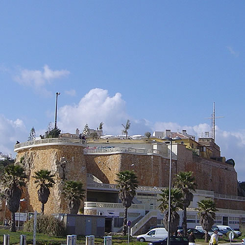
The Fortaleza in Sagres, located at Sagres Point, is historically significant in that it was the place where Henry the Navigator planned out his trip to Africa, which started the `Golden Age` of Portuguese Exploration. The fort is not classically constructed, in the sense that walls block out all four directions: it is more of a wall that protects one side, while the other three sides are protected by cliffs which reach a height of nearly 200 feet. The fort allows visitors a great view of Sagres and Cape Saint Vincent. Opened in the 15th century, it was rebuilt after being attacked by Francis Drake during the years of the Spanish Armada, in the late 16th century.
N268-2 motorway, Sagres

Aljezur Castle
The site of Aljezur Castle was first populated by the Lusitanians, who built a castro, and was subsequently populated by the Romans and the Visigoths. It was the Moors who built a full-fledged castle on this land, using the castle as part of the line of defense protecting Silves, then the capital of Moorish Al-Gharb. In the thirteenth century, the castle transitioned to ownership under the Portuguese crown. The castle rises above the town of Aljezur, sitting on a hilltop 250 feet in elevation. The current wall structure dates from shortly after the Portuguese earthquake of 1755, and rise as high as 15 feet in spots. Of interest on the grounds include towers, silos and houses which have been renovated to look the way they did in the thirteenth century.
Rua Dom Paio Pires Correia, 8670-156 Aljezur

Igreja da Luz de Lagos
One of the older houses of worship in the western Algarve, the site on which the church is located first broke ground in the early 16th century, although the current building dates from the 19th. Inside the church, there are five separate altars, with two located on the left side of the interior and two on the right. The main pulpit, in the middle, is dedicated to Our Lady of the Rosary. The baptismal font is uniquely-designed, with seven edges, each of which signify the seven sacraments.
Avenida dos Pescadores 10L4, 8600-130 Luz

Fortaleza da Luz
Located at the edge of Praia da Luz, the fortaleza was constructed circa 1575 to protect the nearby townspeople from pirate attacks. It was one of the many coastal fortresses that protected the area in and around Lagos, continuing to function as a base for army and navy operations until 1849. At this time, Portugal was less susceptible to attack than ever, and the newly decommissioned fort fell into stages of disrepair. In 1894, it was auctioned off by the government and now operates primarily as a private residence, but portions are open to the public as it is listed as a national historic monument. One of the most important examples of military architecture in the Algarve, we recommend taking a stroll around the fortress`s gardens which overlook the adjacent bayfront.
Avenida dos Pescadores 3, 8600-130 Luz

Praia da Luz
Praia da Luz is well-known for its beautiful, crystal waters, but even during the high season you will notice how cold the sea is! You can expect water temperatures around 65 degrees during the height of summer, and temperatures between 55-60 in the lower seasons. This beach is well-known for its numerous water sports, and you can rent both kayaks and banana boats for fun offshore excursions (currently priced at 10 an hour and approximately 15 per 15 minutes, respectively). Praia da Luz`s secondary beach, the Prainha, is located in front the Fortaleza da Luz. The nearby Rocha Negra cliffs offer a great vantage point looking down on Praia da Luz.
Rua Jose da Conceicao Conde 9, 8600-184 Luz

Praia de Porto de Mos
Approximately 2.5 miles southwest of Lagos city center, Praia do Porto de Mos is the place to go if you`re interested in surfing (including bodysurfing). The reason why it is so popular with that demographic is due to geographic placement; it is the only beach not guarded by the Ponta da Piedade, meaning the winds at the beach are almost always strong. Since it is further away from the city, this beach is less crowded than some of the others. Perfect for families, the beach and waters in and around Porto de Mos are staffed by lifeguards in the summertime.
Largo da Republica, 8600 Lagos
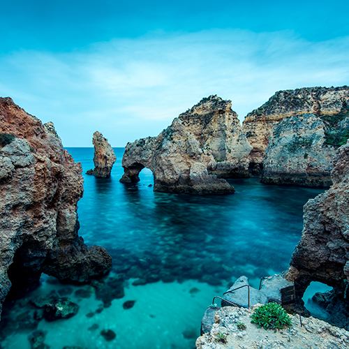
Ponta da Piedade
Perhaps the most popular attraction that draws tourists to Lagos is the Ponta da Piedade, a section of coastline not far from the city center. The rock formation features a number of sea arches, grottos and underground caves. The formations, and the cliffs around them, stand as high as 60 feet above the ocean. You can tour the lighthouse close to the cliff, or you can take a kayak excursion in and around the beautiful rock formations in the water.
Terminus of M536 motorway, 8600 Lagos

Museu de Cera dos Descobrimentos
Located at the northern end of Lagos Marina, as the Bensafrim flows out into the Atlantic, the Wax Museum of Discoveries is spread out across 2,100 square feet and features 22 wax figures and 16 moments in Portuguese history. Among the scenes presented are the wedding of King Joao I to Philippa of Lancaster, the Portuguese explorers rounding the Cape of Good Hope, and the conquest of North Africa. This new attraction opened to the public on October 27, 2014.
Passeio dos Descobrimentos, 8600-302 Lagos

Lagos Marina
Floating down the Bensafrim River, one can enter Lagos Marina after crossing under a small drawbridge. Between the drawbridge and the ocean sits Lagos Marina, a state-of-the-art boating facility which was opened in 1994. The marina can accommodate as many as 460 boats. The marina complex is a mini-destination of its own, including a hotel, restaurants, shops and even green spaces. Here you can charter your own yacht for a relaxing ride or you can choose water sports such as jet-skiing.
Marina de Lagos, Edifício da Administracao, Rua Caminhos de Ferro, 8600-780 Lagos

Mercado dos Escravos
As Lagos is well-known for being a `City of Portuguese Discovery`, sadly it is also well-known for its role in the Portuguese slave trade. Located in the Praca do Infante, the slave market that once operated here was perhaps the first one open for business in all of Europe. The first floor of the slave market building, once repurposed as a customs house, is now a museum dedicated to educating people about the horrors of the Portuguese slave trade.
Rua da Senhora da Graca 26, 8600-315 Lagos

Statue of Henry the Navigator
Located in the Praca do Infante, the statue of Henry the Navigator was built on the 500th anniversary of his death in 1960. Henry the Navigator used Lagos as a jumping-off point to explore faraway lands under the auspices of the Portuguese crown. He claimed Ceuta, Tangier, Madeira and the Azores in the name of Portugal in the 15th century.
Praca Infante Dom Henrique, 8600-315 Lagos

Lagos Esplanade
The Lagos Esplanade, running parallel with the Avenida dos Descobrimentos (a main automobile artery in the city), stretches for about 7/8 of a mile from the Fortaleza da Ponta da Bandeira to the roundabout connecting the Avenida with Rua Infante Dom Henrique. Walking the entire length of the Esplanade will bring you past such sights as the Mercado de Escravos, Praca de Gil Eanes, and the Centro Ciencia Viva.
Avenida dos Descobrimentos and the Bensafrim Riverside, 8600-000 Lagos

Igreja Paroquial de Santa Maria de Lagos
Originally named Igreja da Misericordia (the church adjoining the city`s first hospital), the Parish Church of Santa Maria de Lagos was completed in 1498. When the strong Portuguese earthquake of 1755 destroyed the first building, it was rebuilt on a grander scale and was deemed the local parish church. The facade is flanked by two bell towers. The Renaissance-style doorway leads into a chapel with a beautiful wooden ceiling.
Praca Infante Dom Henrique, 8600-315 Lagos

Igreja de Santo Antonio
This church was conceived as a specific house of worship for members of the Portuguese royal military. It is believed to have been built during the reign of King Joao V (1706-50) and for decades was only open to members of the uniformed services and their families. The building we know today dates from 1769, 14 years after the Portuguese earthquake rocked Lagos and destroyed the original structure. It is noteworthy for its elaborate gilt carvings.
Rua General Alberto da Silveira, 8600-594 Lagos
Castelo dos Governadores
In the 17th century, a large building complex, featuring elements of the Seven Stations of the Cross, was built in Lagos. Today, the only surviving portion of this complex is the Castelo dos Governadores, once owned by the Count of Avintes. The building features both Baroque and Manueline architectural styles. Note the coat of arms above one of the main doorways: it is the old coat of arms of the Kingdom of the Algarve.
Rua do Castelo dos Governadores 6, 8600-315 Lagos

Lagos Castle
Heavily damaged in the earthquake of 1755, the walls and ramparts are the only remaining portions of Lagos`s heavily-fortified castle. The Caliph of Cordoba first built a small castle here in 929, and later the Portuguese crown would further expand the fortification. Working from Lagos Castle, representatives of the Portuguese crown commissioned expeditions in order to discover faraway lands. Henry the Navigator (1394-1460) helped to discover Ceuta, Tangier, Madeira, the Azores, and Cape Verde, all of which would eventually become Portuguese crown holdings.
Rua Bombeiros Voluntarios de Lagos 18, 8600-315 Lagos
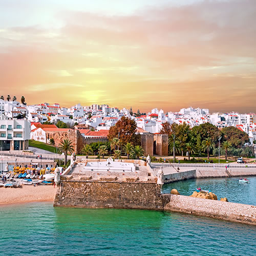
Fortaleza da Ponta da Bandeira
Lagos was a particularly important city for the Portuguese royal navy, and the fort along the Cais da Solaria was built as a response to attacks on the city of Lagos by the Spanish. Construction lasted from 1679 to 1690 and helped to strengthen the city`s defenses against the adversarial Spanish armada. There is a small chapel inside the fort, with azulejos lining the walls.
Cais da Solaria, 8600-645 Lagos

Batata Beach
Batata Beach is perhaps the busiest beach in Lagos, located just minutes from the main square. The beach itself is located on a cove between high cliffs. Even though a lot of people come here, the beach itself is small, meaning in high season you may have to compete for a spot on the sand. The waters off Batata Beach are particularly relaxing, as there is little to no wave activity offshore.
Cais da Solaria, 8600-645 Lagos

Meia Praia
East of Lagos City, Meia Praia is a long stretch of beautiful coastline which could be considered one of the area`s best-kept secrets. Meia Praia isn`t completely untouched -- tourism has found its way to these sandy shores -- but it is a lot quieter than other beaches in the area. After sunning yourself on the sand, enjoy food and drink at your choice of cafes and restaurants inland.
Largo da Republica 34, 8600 Lagos

Autodromo Internacional do Algarve
Opened in 2008, the Algarve International Racing Circuit hosts yearly events such as the Le Mans 1000 Hours of Algarve, the FIA GT Championship, and the World Series by Renault. The 100,000-seat race circuit, located 16 miles north of Lagos in the municipality of Portimao, also includes a go-kart track, a luxury hotel, and a sports complex. The race circuit track is 2.9 miles long and claims a Grand Prix lap record of just 91 seconds.
Sítio do Escampadinho, Mexilhoeira Grande, 8500-148 Portimao

Megalithic Monuments of Alcalar
The area around the Megalithic Monuments of Alcalar was first populated in the third millennium before the Common Era, in what is informally called the Copper Age. Burial mounds were constructed no later than 1600 BCE. Eighteen such burial mounds were constructed. The site as it exists today consists of various mounds with beehive tombs, featuring hidden rooms and side corridors.
Mexilhoeira Grande, 8500-120 Portimao

Roman Villa of Abicada
Four miles west of Portimao`s old town, and adjacent to Portimao municipal airport, is the Roman Villa of Abicada. The settlement was founded in the first century of the Common Era and was populated for the next four centuries. Many of the artifacts uncovered by archaeologists date from the 1st and 2nd centuries of the Common Era, and can be seen up-close at the site. Of particular note are the geometrically-shaped mosaics located on-site.
Caminha da Abicada, Portimao

Alvor Castle
The first settlement built on the site of what is now Alvor Castle was constructed by the end of the 7th century before the Common Era. Hannibal of Carthage conquered the settlement in the year 436, naming it Barcinia. The Portuguese crown rebuilt the castle in the year 1300, and with Silves Castle, it was one of the two strongest fortifications the Portuguese kings cultivated in the southwestern Algarve. The castle was destroyed in the 1755 earthquake, and only ruins remain today.
Travessa do Castelo, 8500-003 Alvor

Alvor Beach
Alvor Beach is situated above five miles west of Portimao and the Praia da Rocha area. If you want to enjoy the sun and surf among smaller crowds than you would see in Praia da Rocha, then Alvor Beach is perfect. Unlike Portimao, much of the growth on and around Alvor Beach has been limited, adding to the beach`s relaxing vibe. This beach is well-known for its sailing, waterskiing, and windsurfing, among other water sports. This beach is accessible to all types of travelers, including those with disabilities.
Estrada da Barca 9, 8500 Alvor

Praia dos Tres Irmaos
Praia dos Tres Irmaos (`Three Brothers Beach`) is the eastern portion of the city beach in Alvor, west of Praia da Rocha and Portimao. Limestone cliffs rise dozens of feet above the shoreline, and many secluded coves dot the coastline. One of these coves offers up a quaint portion of coastline called Prainha (`little beach`). Like many beaches in this area, it is accessible for able-bodied and disabled tourists.
Praia dos Tres Irmaos, 8500-178 Portimao

Praia do Alemao
West of Portimao and Praia da Rocha, the Praia do Alemao (`German`s house`) was so named because it was part of an estate built by a family from Germany. This stretch of beach is less crowded than Praia da Rocha, but still quite popular, especially with locals. At the end of the beach, feel free to explore undersea caves and rock formations.
Urbanizacao Vau da Rocha, 8500 Portimao

Praia da Rocha
Praia da Rocha is more than just a beach, it is a world-renowned tourism destination. It was one of the first beach communities to be developed for tourism in southern Portugal, and today apartments, condos and resorts line the beach and the main drag, Avenida Tomas Cabreira. There are multiple entrances to the beach: one staircase with approximately thirty steep steps, and a walkway which leads to wheelchair ramp access down to the eastern side. Praia da Rocha is a large beach and there will be room for you even when it is inundated with sunbathers. On the main drag, there are lots of restaurants, cafes, shops, casinos, bars and nightclubs.
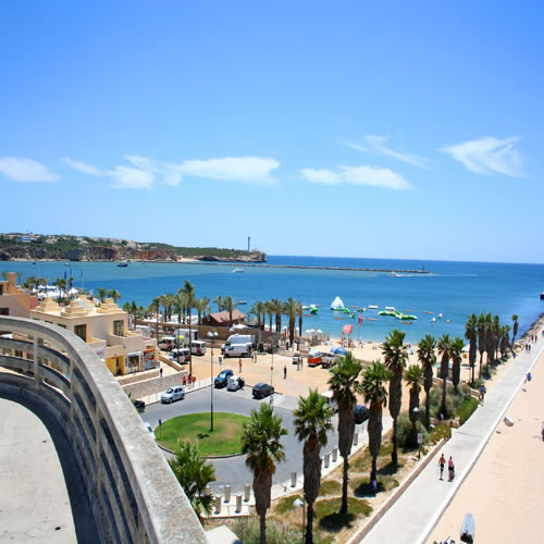
Praia da Rocha Boardwalk
A wooden boardwalk runs along the edge of Praia da Rocha, allowing for access to the beach by both able-bodied people and people with disabilities. There are also many restaurants and bars along the boardwalk, many of which are also wheelchair-accessible. With the advanced facilities located on the boardwalk (jet ski rentals, showers, etc.), you can easily spend an entire day on the beach, on the boardwalk, or in the vicinity.
Avenida Tomas Cabreira, 8500 Portimao
Fortaleza de Santa Catarina
At the eastern end of Praia da Rocha, a large fort built on a cliff sits over the beach and the River Arade. Filipe IV commissioned the construction of the fort during his reign (1621-40). There was already a structure on the cliff before construction began, so it was incorporated into the design. The structure, a hermitage dedicated to Saint Catherine of Alexandria, still stands there today. After the fort was decommissioned, it served as the headquarters of the maritime police, and then as a restaurant and finally a cafe and ice cream shop.
Avenida Rio Arade, 8500 Portimao

Portimao Marina
Portimao`s state-of-the-art marina was opened to the public in 1999. Covering over 60 acres of land and sea, the marina sits at the Arade River estuary, and welcomes boats and yachts up to 50 feet. Also in the marina complex, there are luxury condos, a private beach, restaurants, bars, retail shops, and an oceanic swimming pool.
Ponta da Areia, 8500-345 Portimao

Portimao Museum
Portimao`s industrial history museum is housed in an old cannery, once operated by local company Feu Hermanos, and opened to the public in 2008. Nearly all of the exhibits in the museum tell the history and industrial heritage of Portimao and its residents, in particular industries such as fishing, canning and shipbuilding. Even though it has only been open a relatively short time, the Portimao Museum has already won the Council of Europe Museum Award (in 2010).
Rua Dom Carlos I, Zona Ribeirinha, 8500-607 Portimao

Portimao Riverside (Ribeirinha)
The pedestrian avenue along the riverside (called `zona ribeirinha` in Portuguese) begins next to the Sao Francisco marine dock near Estrada da Rocha and stretches along the Arade River estuary for three-quarters of a mile, ending with a bust of a face, installed on the riverwalk near Rua Infante Dom Henrique. This statue, called `Pensando Omar` (a homonym, as `o mar` means `the sea` in Portuguese), was commissioned by the City of Portimao and was sculpted by artist Assem al-Bacha.
Zona Ribeirinha, 8500 Portimao

Igreja da Nossa Senhora da Conceicao
This church is the largest Roman Catholic house of worship in Portimao, and is also known as the `Mother Church` (`Igreja Matriz de Portimao`) Built in 1476 and remodeled in the 16th century, the church is a melange of Gothic, Renaissance and Manueline architectural styles. The current church was built in the decades following the devastating 1755 earthquake. Of particular note in the church are the detailed azulejos lining the walls, as are the murals painted on the side altar walls.
Rua da Igreja, 8500-581 Portimao

Forte de Sao Joao do Arade
The first fortifications built on the beach in Ferragudo were constructed in 1520, but it took nearly a century before the Portuguese crown decided to build a seaside fortress to the east of Portimao. It saw battle during the Portuguese Restoration War, and later emerged unscathed from the 1755 earthquake, due to its position on top of soft rock. The Baroque-style fort was decommissioned in 1896 and restorations began shortly after being recognized as a national monument in 1975.
Rua Doutor Coelho de Carvalho 8, 8400 Ferragudo

Slide and Splash
Open since 1986, Slide and Splash is the largest water park in Portugal. Located on a plot of 11 acres about 20 miles northeast of Lagos, Slide and Splash offers ticketholders the opportunity to try out some of the more daring water slides and amusements in Europe, such as `Kamikaze`, `Tornado`, and `The Big Wave`. There are also live shows and restaurants on the property, as well as four full acres of grassy areas.
Estrada Nacional 125, Vale de Deus - Estombar, 8401-901 Lagoa

Carvoeiro Beach
Carvoeiro is well-known today as a resort town, but once upon a time it was a small fishing village. Whitewashed villas are perched atop cliffs of limestone surrounding Carvoeiro Beach, which buzzes most of the year with tourists. This beach is lined with small restaurants and cafes. It is also accessible to people with mobility impairments or disabilities.
Largo da Praia 16, 8400 Carvoeiro

Ponte de Silves
The Ponte de Silves`s first written mentions in journals and literature occurred in the 15th century, although it is possible that a bridge existed on the same site, crossing the Arade River, as far back as the time of the Romans. The bridge, built with local sandstone, was renovated in 1716, and carried road traffic into Silves until 1950. At that time, a concrete bridge was built close by and the older bridge became a pedestrian-only crossing. The bridge is supported by five round arches, some of which sport freshly-decorated flowerbed acronyms, similar to the ones seen at Silves Cathedral.
Ponte Romana, 8300-126 Silves

Silves Almedina
Silves`s medina is one of the most cohesive Moorish medieval cities left standing in Portugal today. The area on which the medina was built dates from the time of the Romans, and eventually was the capital of the Moorish kingdom of Al-Gharb (from which the name `Algarve` is derived). The main north-south road in the medina is the Rua da Se, formerly called the Rua Direita, which is accessible via the Almedina Gate (also called the Loule Gate), as the Rua Direita connected Silves with the provincial capital of Loule. The Rua de Sancho I connects the western and eastern doors together. A lot of the walls that are still standing date from the time of Ibn al-Mahut, the last Moorish king of Silves, who ruled during the thirteenth century.
Rua da Cadeia 2, 8300-117 Silves

Silves Cathedral
Silves Cathedral is considered to be the most notable Gothic building left standing in all of the Algarve. The building we see today dates from the 18th century, although it was rebuilt at that time to resemble the circa 1470 Gothic structure which included three chapels and a three-aisled nave. (More Baroque additions from that time were suppressed, shortly after the cathedral became a Property of Public Interest in the 1920s.) Silves Cathedral was considered one of the most important seats of influence for the Roman Catholic Church in the Algarve, at least until the construction of Faro Cathedral in the 16th century.
Rua da Se, 8300-140 Silves

Silves Castle
One of the oldest national monuments in Portugal, Silves Castle dates from at least the time of the Moors. The Moors were the group that built and fortified the castle to the manner in which tourists see it today, making it one of the best examples of Moorish defensive architecture in the country. The Portuguese crusaders stormed the castle and conquered it in 1189, and by the thirteenth century, it was firmly and continuously in Portuguese control. Henry the Navigator was named Silves`s alcalde (mayor), ruling from the castle from 1457 until his death three years later. More Moorish structures inside the castle walls were found as a result of archaeological excavations which occurred between 2005-2008.
Rua da Cruz de Portugal, 8300-135 Silves

Forte de Nossa Senhora da Rocha
The fortifications located on the current grounds of the Forte de Nossa Senhora da Rocha, in the town of Porches, most likely date from the era of the Visigoths, which aimed to protect the stretch of land between what is now Faro and Lagos. The first recorded mention of this fort came in the thirteenth century, during the time in which the Moors ruled the Algarve. The fortress as we know it today was built in the fourteenth century at the request of King Dinis. The fortress was lovingly reconstructed and renovated in the 1960s, but a devastating in earthquake in 1969 nearly undid all of the work; the current look was achieved shortly after it became a Property of Public Interest in 1992.
Off the M530 motorway, Porches

Praia do Vale do Olival
The narrow Praia do Vale do Olival is located on the roughly 1000 feet of sand at the very eastern end of Praia da Armacao de Pera, adjacent to the Holiday Inn Algarve. It is connected by a tiny trail cut through a patch of vegetation with the very isolated Praia dos Beijinhos, which is a place ideal for peace and quiet for those who are more able-bodied. The waters at Vale do Olival rank among the least polluted in Portugal and have received high ratings by the Portuguese Environment Agency for the last five years in a row.
Avenida Beira Mar 66, 8400 Porches

Praia da Armacao de Pera
The western portion of the promenade which stretches along the beach in Armacao de Pera begins at the remains of the Fortaleza. A number of hotels and apartment complexes stand behind the promenade separating the buildings from the beach. This beach is well-known for its wide open spaces, beautiful sand, colorful fishing boats sitting just offshore, and the nearby restaurants serving the catch of the day. Armacao de Pera`s beach is a wheelchair-accessible beach.
Avenida Beira Mar 3, 8365-101 Armacao de Pera

Fortaleza de Armacao de Pera
The Fortaleza (also called the `Forte de Santo Antonio da Pedra da Gale`) was built on the site of an old Lusitanian castro which dated from the time of the Roman conquest of the Iberian Peninsula. The current fort dates from 1571, commissioned by King Sebastian. At the time, the coast around Armacao de Pera was vulnerable to attacks from pirates originating from the Barbary Coast. The Capela de Santo Antonio, located inside the fort, dates from 1720. In 1978, the fort and chapel were named national `Properties of Public Interest`.
Largo da Fortaleza, 8365-101 Armacao de Pera

Aqualand Algarve
Twelve miles northwest of Albufeira, the Aqualand Algarve theme park is one of Portugal`s most popular water parks. It is also the only Portuguese `Aqualand` theme park franchise. There are water park slides, lazy rivers and pools for all ages. The Congo River lazy river is 880 feet in length and the Kamikaze water slide drops you from a height of 120 feet down to the pool below in just four seconds -- the fastest water slide in Portugal. The park is open from the second week in June to the last week in September. Hours are 10 a.m. to 5 or 6 p.m. depending on the month.
Estrada Nacional 125 - Sitio das Areias, 8365-908 Alcantarilha

Zoomarine Algarve
Zoomarine Algarve is a fun theme park located about nine miles northwest of Albufeira in the parish of Guia. A cross between `Busch Gardens` and `Sea World`, Zoomarine Algarve is a fun place where kids and adults alike can learn about tropical birds, sea lions, dolphins and seals by seeing them up close. In addition, there is a beach with a lagoon-style wave pool, an IMAX 4D cinema, and an aquarium featuring marine animals such as sharks. Zoomarine Algarve is open from the last week in March until the last week in November.
N125, kilometer 65, Guia, 8201-864 Albufeira

Albufeira Marina
The current marina in Albufeira was opened with much fanfare in 2005; newspapers and television were calling the Marina perhaps `the safest in the entire country`. Around the marina, there is a busy entertainment complex with shops, restaurants, bars and a recreational center. You can take your own private boat out for a special charter or you can inquire about water sports such as jet skiing.
Rua da Orada, 8201-918 Albufeira

Elevador do Peneco
The 90-foot elevator connecting Albufeira city with Praia do Peneco was built in 2008, costing the city €687,000 ($1.2 million in US dollars accounting for inflation in 2017). It can safely hold 13 people at a time and it has helped the beach cultivate a reputation for being friendly to those with accessibility issues.
Esplanada Doutor Frutuoso da Silva 5, 8200-123 Albufeira

Praia do Peneco
Praia do Peneco is also known as `Praia do Tunel`, and it is so named because one of the entryways to the beach is a 60-foot tunnel that links the town with the coast below. A promenade along the beach ends at Xorino Grotto, where it is believed that the Moors camped out after the Portuguese crown conquered Albufeira. One of the two main beaches adjacent to Albufeira city, this beach is perhaps the most accessible for those with disabilities.
Esplanada Doutor Frutuoso da Silva 9, 8200-076 Albufeira

Igreja Matriz de Albufeira
The main church in Albufeira is located on Rua da Igreja Nova and is so named because it was built in 1782, many years after the original church (which was once a mosque) was destroyed in the devastating 1755 earthquake. The single-nave church was rebuilt in the Neoclassical style and has four separate side altars. The altarpiece was painted by Samora Barros (1887-1972) and is comprised of a large mural dedicated to Our Lady of the Conception (you may notice that this church is also called Our Lady of the Conception, or Nossa Senhora da Conceicao, by locals).
Rua da Igreja Nova 183, 8200 Albufeira

Albufeira`s Old Town (Centro Antigo)
Approximately the size of four football fields, the compact Old Town is centered around streets like Avenida da Liberdade, Rua Candido dos Reis, Rua Joao de Deus, Rua 5 de Outubro, Rua Miguel Bombarda, and Avenida 25 de Abril. Sights of note in the Old Town include the Jardim Publico, the Igreja de Sant`Ana, the Igreja Matriz, and the Municipal Archaeological Museum. Lots of bars and restaurants are located along Rua Candido dos Reis and Avenida da Liberdade in particular.
Travessa Candido dos Reis 2, 8200-013 Albufeira

Praia dos Pescadores
Praia dos Pescadores is one of the two main beaches in Albufeira, the other being the Praia do Peneco. An escalator connects the Old Town with the beach below. The name in Portuguese means `fisherman`s beach` and it is so named because, before Albufeira became a tourist haven, the beach was the spot where fishermen anchored their boats. In a nod to this tradition, the area around the beach serves some of the best seafood you can find in Albufeira.
Rua Almirante Gago Coutinho, 8200 Albufeira

The Strip
If the area near Praia do Peneco is called `the Old Town`, the Strip can be referred to as the `New Town`. The Strip`s official name is Avenida Doutor Francisco Sa Carneiro, and it is broken up into two unofficial parts: the `north Strip` in the Montechoro neighborhood and the `south Strip` in the neighborhood of Areias de Sao Joao. The south Strip is packed with bars, restaurants and shops geared toward tourists, while the north Strip is quieter and more upscale, with clothing boutiques and wine shops.
Avenida Doutor Francisco Sa Carneiro, 8200 Albufeira

Paderne Castle
The first castle to be built on this land dates from the Neolithic or Cacholithic era. The structure we know today was constructed by the Berbers in the 1100s, after four centuries of intermittent work. The Portuguese crown seized control of Paderne Castle in 1248. Inside the castle, the chapel (now in ruins) was built on the site of a mosque. The castle has been a national monument since 1998. Paderne Castle is believed to be one of the castles illustrated on the Portuguese flag.
Off the A22 motorway, Paderne

Torre da Medronheira
The watchtower was built in the 1500s, during the reign of King Joao III. The King wanted a tower to be built so corsairs from Castile, Morocco and further afield could be monitored and attacked if necessary. At the time, there were many corsairs sailing around Portugal`s southern coast, only coming ashore to kidnap locals (later selling them as slaves). The tower is well-preserved and is open to the public today.
Rua da Torre da Medronheira 23, 8200-594 Olhos de Agua

Praia da Falesia
Over three-and-a-half miles in length, the Praia da Falesia is one of Portugal`s longest beaches. It is situated between the city of Albufeira and the city of Vilamoura. The word `falesia` in Portuguese means `cliff`, and you will find cliffs bordering the beaches on nearly all possible sides. Stairs connect the town above the beach to the coast below. Restaurants and bars dot the edge of the beach. In the off-season, the beach can be very peaceful. In the summertime it is very popular.
Aldeia da Falesia, 8200-593 Albufeira

Rocha Baixinha Beach
Rocha Baixinha Beach (also called Praia dos Tomates) is the stretch of beach between Praia da Falesia and the Vilamoura city limits. This beach is particularly well-known for being an exclusive fun-in-the-sun getaway spot for Portugal`s political elite. The beach`s alternate name, translating to Tomato Beach, comes from the tomato plants growing in main view at one of the beach`s access points. Since 2003, this beach has been Blue Flag certified, meaning it has achieved a reasonably high `clean environment` rating from the European Union.
Praia Rocha Baixinha, 8125 Vilamoura

Vilamoura Marina
Life in Vilamoura is centered around the marina, which is the largest in Portugal. The town sprung up around the state-of-the-art marina, which first opened for business in 1974 and accommodates over 900 boats during the high season and 1,200 during the low season. In addition to boating, yachting and water sports, Vilamoura Marina is well-known for its extensive shopping options (ranging from the traditional to high-end luxury).
8125-507 Quarteira

Roman Ruins at Cerro da Vila
The area around Cerro da Vila had been inhabited since the Bronze Age; within a generation, it had been used as a cemetery. The Romans conquered Albufeira in 27 BCE and the invading forces built the villa in the years afterward. It had been populated by the Romans, the Visigoths and the Moors. The ruins show structures built by the Moors, proving its habitation as many as ten centuries after its origins. Only crumbling walls stand today where there were multiple residences and Roman-style baths. The ruins are open to the public every day of the week except for Mondays and Tuesday mornings.
Avenida Cerro da Vila 2, 8125-507 Quarteira
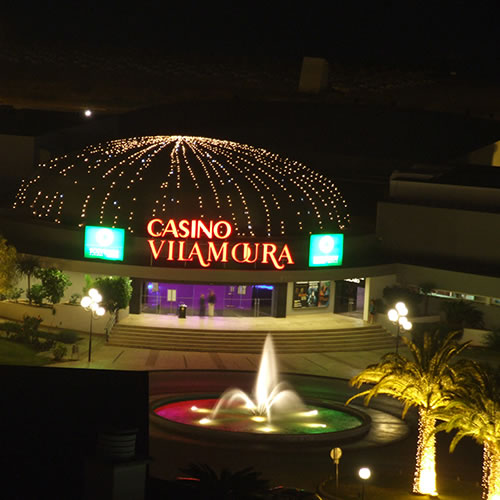
Casino Vilamoura
Vilamoura`s most iconic casino is owned by the Solverde Group and opened to gamblers for the first time in 1996. Casino Vilamoura offers 23 table games, over 500 slot machines, and nine poker tables. In addition, there are three restaurants, a bar/lounge (`The Big Bar`), and space for two rotating Vegas-style stage shows.
Praca Casino Vilamoura, 8126-908 Quarteira

Vilamoura Beach
Within walking distance of the Marina and many sights throughout town, Vilamoura Beach was built from scratch in the 1970s, as most of the area was. Visit Portugal, the national tourism board, notes that Vilamoura Beach has some of the top restaurants and bars in all of the Algarve. It is a very popular and crowded urban beach, and is perhaps the local beach that is easiest for disabled people to access. Vilamoura Beach stretches on past the city of Vilamoura to Quarteira, a city immediately adjacent.
Rua do Oceano Atlântico, 8125-406 Quarteira

Quarteira
Inhabited since the time of the Romans, Quarteira as we know it today was recognized as a town in 1916 and as a city in 1999. Vilamoura and Quarteira are essentially fused together, with Vilamoura being created from scratch, building up around Quarteira starting in the 1960s and 1970s. Including Vilamoura, the population of Quarteira numbers over 21,000. Originally an agricultural and marine economy, Quarteira`s fortunes are now strongly tied to the tourism industry.

Forte Novo Beach
Situated on the sea just south of Quarteira, Forte Novo Beach is so named due to its history as the site of a fortress. Originally built in the 1500s, the new fort (`forte novo`) was constructed two centuries later. Like the beach in Vilamoura, Forte Novo Beach is quite accessible for all people regardless of mobility, and regularly receives its share of local sunbathers in addition to tourists.
Rua do Poco Romano, 8125 Quarteira

Praia de Vale do Lobo
The 1.2-mile stretch of beach at Vale do Lobo has been popular with vacationers for decades. In 1962, the Vale do Lobo Algarve Resort opened its doors. It was the first luxury resort to be built in the Algarve, but it definitely wasn`t the last. This beach is considered one of the three points in the Algarve`s `Golden Triangle`. Much of this beach is owned by the Vale do Lobo Algarve Resort, the largest luxury hotel and resort in Portugal.
Estrada da Horta 423, 8135-107 Vale do Lobo

Praia do Ancao
Located in Ria Formosa Natural Park, the Praia do Ancao is located east of Quarteira, and almost due south of Loule. The beach and its accompanying sand dunes are not far from wooded areas populated with tall pine trees. There are lots of restaurants, bars and sporting activities (from parasailing to aerobics and football) close by. Many local and international celebrities have been known to sun themselves at Praia do Ancao, boosting the beach`s popularity immensely.
8135-162 Almancil

Aquashow
Located four miles northeast of Vilamoura Marina, Aquashow is a mix of water park and amusement park. Aquashow has the second-longest roller coaster in Europe (2,400 feet and featuring a drop of nearly 80 feet), a selection of water slides, lazy rivers, pools, and three live shows (including a reptile show). In addition, there is a wax museum of Portuguese history at the park, which was commissioned by the same special effects masters Madame Tussauds in London uses for their wax figures.
Estrada Nacional 396, 8125-303 Quarteira