ESTEPONA - NEIGHBORHOODS


Estepona`s Historic Center (Centro Historico)
The historic center of Estepona (pop. 66,000) is the portion of the town that was largely developed between the fifteenth century, when the town was conquered by the Castilians and Aragonese from the Moors, and the late nineteenth century. It is roughly bounded by Avenida Juan Carlos I to the southwest, Avenida España to the southeast, and Avenida Andalucia serving as a ring road around the historic center. This covers an area of roughly 171 acres, or a little over a quarter of a square mile. The houses in the historic quarter typically date from the eighteenth or nineteenth centuries, with second stories added to most houses as an afterthought, usually in the twentieth century as the town grew and modernized. As late as the late 1950s, many houses in the town were not wired for electricity and did not have proper sanitation links. Today, all houses in Estepona feature amenities of a 21st century standard.
Dozens of plazas dot the historic center of town, with the most noteworthy being Plaza Fuerzas Armadas in the west, Plazas Pozo Prado and Almengual in the southwest, Plaza de las Flores and Plaza de Manilva in the central portion of town, Plaza del Ajedrez and Plaza Nuestra Senora de los Remedios in the northern portion just south of Avenida Andalucia. After Plaza Ortiz, the easternmost plaza in the historic quarter, the Avenida España changes names to the Avenida del Litoral.
Estepona`s historic center is considered one of the best-preserved of all the traditional Andalucian coastal towns. Unlike many historic quarters across Spain, it is a largely residential area, and as such there are many shops, restaurants, bars, and cafes catering to the local population primarily over tourist crowds. You will find the largest cluster of tourist-oriented restaurants and cafes along Avenida España and Calle Real. The major northern artery through the historic quarter is Calle Terraza, while the major southern arteries are Calle Calvario and Calle Tajo. The southern boundary, Avenida España, separates the town from Playa de la Rada, the most accessible beach from the historic center.
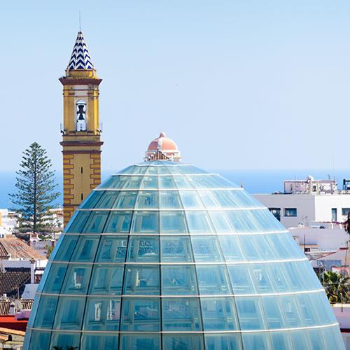
Sights of interest in the historic quarter include the Castillo de San Luis, the Torre del Reloj, the Iglesia Santa Maria de los Remedios, the botanic garden Orquidario, and the flowerpot district (streets such as Calle Papuecas, Calle Silva, Calle Pintado, and Calle Barranca), which is largely pedestrianized. Also in the historic district you will find colorful murals, an art project sanctioned by the local government; there are 19 murals around the city.


Marina District and Port of Estepona
From the historic center, you can walk down the Promenade (officially called the Paseo Maritimo Pedro Manrique) approximately 0.6 miles to its end point, where Avenida España is renamed Avenida del Carmen. This area is the heart of the Marina district, also referred to as the Fishermen`s Neighborhood (Barrio Pescadores).
South of the Plaza Virgen del Carmen, you will find Estepona`s lighthouse, Punta Doncella Lighthouse. Punta Doncella is the land mass on which the modern Port of Estepona is situated. The fishing port (puerto pesquero) is located closest to the lighthouse, on the street of the same name, Calle Puerto Pesquero. The modern marina and charter ferry port is on the western side of Punta Doncella.
Playa del Cristo, Estepona`s second-most popular beach, is located on the western side of Punta Doncella and the Port. In the summer months, the Port (specifically the bars and nightclubs on Avenida Luis Braille and Avenida Virgen del Puerto) explodes with nightlife activity, and you can dance the sevillana until the early hours while having some drinks at the Port.

Casares
The town of Casares (pop. 4,051) is located three miles south of the Sierra Crestellina mountains and five miles north of the Roman baths of Hedionda. Casares was settled by the time of the Romans, as it was believed that Julius Caesar stayed in the town while he was bathing at the Hedionda baths. As the story goes, the water supposedly cured Caesar of a liver ailment, and as a result, Casares was allowed to mint its own Roman coins. Modern-day Casares grew around Casares Castle, which was built by the Moors in the 12th century. Casares Castle was noteworthy in protecting the town against Napoleonic forces in the early nineteenth century; out of all the Andalusian towns, only Casares and Cadiz escaped capture. Many of the buildings today feature Moorish architectural influences and are built on, or into, cliffsides. The main streets in Casares are Calle Fuente (eastern artery), and the north-south Calle Villa, Calle Carrera, Calle Molinos and Calle de Juan Ceron.

Casares Costa
A beach community, Casares Costa is located in an area which also goes by the names Casares del Mar to the north and Marina de Casares to the south. The MA8300 motorway connects the inland portion of Casares to Casares Costa, and the A-7 motorway passes through town. A number of villas and apartment rentals branch off from the A-7 motorway and away from the two beaches along the coast, Casares Beach and the larger Torre de la Sal Beach. Casares Costa is perhaps more popular with the golfing crowd, as there are three resorts (Casares Costa, Doña Julia, and Finca Cortesin) just a short distance away from the coast.

Puerto de la Duquesa
Two miles south of Casares Costa is the urban developments known as La Duquesa, centered around Puerto de la Duquesa, the fishing port and modern-day marina, and the old town half a mile to the south, which was built around the eighteenth-century Castillo de la Duquesa. The Castillo de la Duquesa was built on ruins of an ancient Roman villa.
North of Castillo de la Duquesa, there is an amusement park called Duquesa Park, and as you drive up the N-340 motorway toward Puerto de la Duquesa, you will notice the La Duquesa Golf and Country Club on your left. The majority of restaurants, bars and clubs can be found north of the port in a neighborhood called San Luis de Sabinillas, where the local bus stop is also situated. Focus on the Promenade (Paseo Maritimo) and the Calle Duquesa de Arcos.

Cancelada
The easternmost suburb of Estepona, the town of Cancelada is located on the eastern bank of the Rio Guadalmansa. South of Cancelada there are two beaches, one on the western bank of the river (Guadalmansa Beach, with the Torre de Guadalmansa situated on the eastern side of the beach), and one on the eastern bank (Saladillo Beach). The most noteworthy points of interest in Cancelada are the arch visitors see when entering town, and the Parroquia Purisimo Corazon de Maria, the only church in Spain that practices perpetual adoration.