LASSITHI - ATTRACTIONS


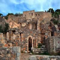
The islet of Spinalonga is located in the north-eastern side of Crete, between the town of Elounda and the golf of Mirabello. Its name is Italian and means long thorn. In Greek, its official name is Kalidon islet. Its history begins in 1579, when the Venetians built a fortress on the islet to protect their occupations in Crete and their fleet, settled in the harbor of Elounda, from the Turkish invasions. This islet was also a refugee for Christians in times of war, since the high walls that reach the seaside could prevent any disembarkation. In 1715, however, the Turks managed to defeat the Venetians and occupy Spinalonga. The island remained in their possession until 1905, when Crete won her freedom. After that, the island was used as a leper colony. All lepers of Crete, who were previously living in caves, away from civilization, were now taken to Spinalonga, where food and medical care was provided to them. In 1957, though, the drugs to cure this disease were finally found and the lepers gradually abandoned Spinalonga. The last inhabitant was a priest, who left in 1962.
Today thousands of tourists visit Spinalonga by boat from Ayios Nikolaos(1 hour), Elounda (15 minutes) and Plaka each summer as it is the most popular archaeological site in Crete after Knossos. Strolling around the island takes about an hour, but the serenity of the place and the remnants of its recent history will certainly tempt you into spending much longer. A left turn by the old town hall takes you down to the beautiful seafront; take advantage of the opportunity to take some time for a swim here.
This is one of the most important religious places of Minoan Crete. The Cave is situated at the Lassithi plateau, some 40 miles away from Agios Nikolaos. The cave of Psychro is one of the most important cult places of Minoan Crete. The use of caves as cult places was one of the basic characteristics of the religious beliefs of the ancient Cretans. Cult practice probably begun in the Early Minoan period (2800-2300 B.C.) although traces of an even earlier occupation are preserved in the antechamber but the most important finds date from the Middle Minoan period (1800 B.C.) and later, as it was used for many centuries, until the Geometric (8th century B.C.) and the Orientalising-Archaic period (7th-6th century B.C.). The finds prove that it was visited as late as the Roman period. The excavators and several scholars have identified the cave as the famous Diktaian Cave, where Zeus was born and brought up with the aid of Amaltheia and the Kouretes, and which is connected with myths as this of the seer Epimenides who slept here, or the coupling of Zeus with Europa. Pilgrims dedicated many offerings, such as figurines of humans, gods, animals, double axes etc. The cave is found at a height of more than 3,000 feet and access to it is possible via an uphill path, starting from the public road.
Spread over an area of 15 square miles, the Lassithi Plateau is one of the most fascinating elements of the topography of Crete and has a rich history dating back to the Neolithic period. It is often described as the plateau of windmills as it numbers nearly ten thousand windmills. The plateau is dotted with about twenty Greek villages, each more picturesque than the other. The highly fertile plateau, endowed with an abundance of greenery, is watered by the melting snowcaps of the Dikti Mountain that form a natural fortification around the plateau. Although tourism has become an integral part of the local economy, vegetables and fruit trees are widely grown on the plateau. In fact, the plateau of Lassithi is one of the most fertile regions of Greece and gives high-quality products, such as apples, pears, walnuts, cherries and almonds.
The old windmills, with their torn white-cloth sails, make a spectacular sight set against the backdrop of Dikti Mountain. Most of these have, however, fallen to disuse and have turned into signposts for local taverns. However, others have been restored or new, modern windmills were constructed to get a better use of the wind that blows often over the plateau. One of the high points of the plateau is the Dikteon Andron, a cave explored by the British archaeologist David Hogarth. Standing at an elevated point on the plateau, the cave, according to Homer, was the place where Rhea hid baby Zeus, the supreme deity of the Greek pantheon, from his father Cronos to get raised there by a nymph. The cave has some interesting stalactites and stalagmites and remains of early cults. There are also a number of churches and monasteries in the area that are worth visiting.
Located 7.5 miles north of Palekastro (or Paleokastro), on the northeastern side of Crete, the monastery was founded in the mid 15th century but it was devastated during a severe earthquake in 1612. The Venetians contributed in the reconstruction of the monastery, but it was again destroyed during the Ottoman conquest of Crete. The monastery is built in a remote location and its architecture looks like a castle. In the first years of its operation, it was named Panagia Akrotiriani, which means Virgin Mary of the Lighthouse. It was renamed during the Turkish domination. The main building is three-storied including the monk cells, rooms and storage areas. It is definitely one of the most imposing monasteries in Crete. Currently the monastery seems to own a huge stretch of land in the northeast of Crete. This is one of the main reasons that the area has retained its unspoiled and natural landscape. The monastery is dedicated to Virgin Mary and Agios Ioannis Theologos (Saint John the Theologian). Today it hosts a museum with Byzantine icons and several interesting engravings. The rooms and halls include historical exhibits that reflect the monastery`s role during the Byzantine period. The exhibits also depict the way of life of the monks who kept themselves occupied with various activities. Near the monastery there is a small cave which functioned as a shelter in World War II.
Located 1 mile outside Milatos village, it has a historical and sentimental importance for the locals as this is where about 3,600 people were slaughtered there by the Turks in February 1823, during the Revolution. In an effort to save themselves, the residents of Milatos found shelter inside the cave. The men were protecting the entrance and the Turks had circled the cave, not letting them out. Two weeks passed, from February 3rd to 15th, and the Greeks were suffering from hunger and thirst. Exhausted as they were, they took a brave decision: to escape the cave and fight the Turks, hoping that some of them would survive. However, the Turks brutally killed most of them, the 18 priests were burned to death and those who survived were sold as slavers to Egypt. To commemorate this tragic event, a small church of Saint Thomas was built inside the cave in 1935 and a memorial to host the bones of the killed people. A small service is held every year in this cave to their memory. The cave itself is quite large, 240 feet long and 200 feet wide. It has eight entrances and the height varies from 3 to 9 feet. Ancient remains have been found inside that testify the presence of people in the Neolithic times. To go to the cave, you park your car in the valley beneath and then take a narrow footpath on the slopes of a gorge, about 700 feet long.
The uninhabited islet of Chrissi (which means golden island in Greek) lies in the Libyan Sea, at a distance of 8 nautical miles from Ierapetra town. The unofficial name of the islet is Gaidouronissi (island of donkeys). It is nearly flat and its highest point is only 100 feet high. Visitors who wish to spend a few hours in Chrissi can enjoy the small sandy beaches and swim in the turquoise waters of the sea. Belegrina beach is the most popular and visitors have the opportunity to view fossilized sea shells of thousands years old there. Among the historical sites to see on the island, you will find the small 13th century church of Agios Nikolaos, Roman graves and an old lighthouse. Due to its unique and fragile ecological system, the islet of Chrissi has been included in the NATURA 2000 Program, a European initiative to protect places of natural beauty and ecological interest. Visitors can go to Chrissi by boats that depart from Ierapetra in the morning and return in the afternoon.
This is a complex of small islands, north of the bay of Sitia, about 10 nautical miles away from the city port. The complex is made up of four rocky uninhabited islets: Giannisada, Dragonara, Paximada and Paximadaki. In antiquity, the islets belonged to Itanos. According to legend, Dionisades was a sacred place dedicated to the worship of Dionysus, after whom the complex was named. Dragonara is the only islet of the four with some vegetation, and the municipality of Sitia has made plans for a wildlife park, as well as hostels for accommodation. The islets of Paximadi and Paximadaki are interesting, due to the rare bird species that nest there. Unfortunately, access to the islets is possible only by private or rented yacht.