UNESCO WORLD HERITAGE SITES OF THE CARIBBEAN

The Blue and John Crow Mountains
The Blue and John Crow Mountains are located in the verdant forested mountain region in southeastern Jamaica. It is the only national park in the country covering over 101,000 acres, and includes the highest point in Jamaica; the Blue Mountain Peak soaring to 7,402 feet tall. The park features over 9 miles of hiking trails, camping sites, the largest butterfly in teh western hemisphere, hundreds of flowering plants and birds, countless cascading waterfalls, lots of flora and fauna, a nature lover’s paradise. The crisp, clean air, lush terrain, and vibrant wildlife await in the park, which covers about 20% of the island’s landmass. The extensively forested mountainous region was inscribed on the UNESCO World Heritage list in 2015 for its natural and cultural heritage, the park includes three recreational areas; Holywell, Portland Gap, and the Blue Mountain Peak Trail. The area is part of one of the 78 most irreplaceable protected areas for the conservation of the world’s amphibian, bird, and mammal species, along with globally endangered species that include several frog and bird species.
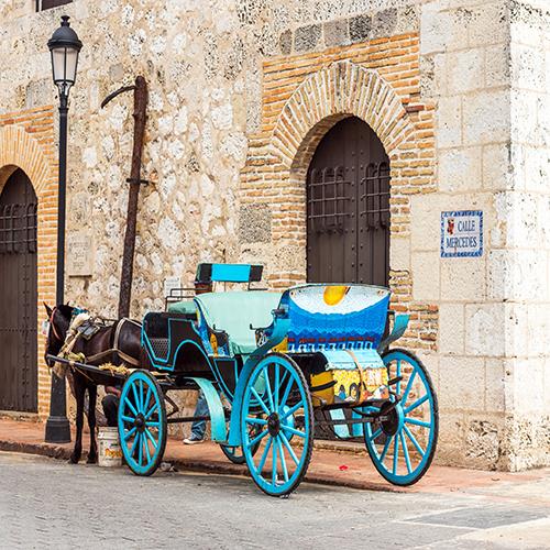
Colonial City of Santo Domingo
The charming colonial city of Santo Domingo is where Christoper Columbus tried to settle in the “New World” several times before getting it right, he arrived on the island in 1492, and the town was founded in 1496 by the Spanish. Santo Domingo became a symbol of colonial dominance in the Caribbean, it was inscribed on the UNESCO World Heritage Site in 1990, home to the first cathedral (Catedral Primada de America), hospital, customs house, the first stronghold (Fortaleza Ozama), the oldest street (Calle Las Damas), and university in the Americas. The old parts of the city are historical treasures, laid out in a grid pattern which became the model for almost all town planners in the New World. A lively, thriving metropolis, the capital of the Dominican Republic, and the largest city in the Caribbean by population. Zona Colonial is set in the heart of the city is decorated with a maze of narrow cobblestone streets, brimming with beautiful colonial-era architecture, a vibrant cultural institution, elegant restaurants, sidewalk cafes, and bustling clubs. The Chu Chu Colonial train takes visitors on a 45-minute ride of the area, picnic on the lawns of the National Botanical Garden which is the largest in the Caribbean, and stroll down the Malecon at sunset for spectacular sea views.

The Antigua Naval Dockyard and related archeological sites
The Antigua Naval Dockyard also known as Nelson’s Dockyard and its related facilities were built at English Harbour, a natural harbor and settlement set on a series of deep narrow bays in the extreme south on the island of Antigua in Antigua and Barbuda. The former British Navy base is located in Saint Paul’s Parish in Antigua, it displays restored 18th and 19th-century buildings, and other historical artifacts from the colonial period of the dockyard, especially during the time it was commanded by Horatio Nelson. With the picturesque combination of narrow bays surrounded by lush verdant hills, the view of the dockyard from Shirley Heights is one of the most breathtaking in all of the Caribbean. The dockyard and related archeological sites in the form of fortifications were inscribed on the UNESCO World Heritage Sites list in 2016. The dockyards were built at the end of the 18th century by enslaved African laborers from plantations in the vicinity. It aimed to protect the interests of sugar cane planters at a time when European powers were competing for control of the Eastern Caribbean. Antigua’s location as a front-line naval dockyard facility gave the British navy a strategic advantage over its rivals at a crucial point in history. Nelson’s Dockyard is the host of Antigua’s sailing and yachting events such as the Antigua Sailing Week, the Antigua Charter Yacht Meeting, and the International Optimist North American Championships in 2015/2016. The dockyard is named after Admiral Horatio Nelson, who lived in the Royal Navy Dockyard from 1784-1787. The UNESCO Site here also contains the Clarence House, and Shirley Heights.

The Morne Trois Pitons National Park
The Morne Trois Pitons National Park is centered on the 4,402 foot tall Morne Trois Pitons volcano in the central and southern highlands of the Lesser Antilles in Dominica. The park was the first in Dominica and protects a scenically striking part of teh country covering 7,000 hectares filled with lush verdant forests, 50 fumaroles, 3 freshwater lakes, 5 volcanoes, deep canyons, hot springs, rivers, creeks, waterfalls, and even a “boiling lake”. The park is rich in biodiversity and boasts dramatic landscapes and exotic beauty and includes the two largest lakes in the country; Boeri Lake, and Freshwater Lake, it also includes Titou Gorge, Middleham Falls, and the Emerald Pool. Morne Trois Pitons includes large tracts of the most extensive undisturbed tropical forest in the Lesser Antilles, and the headwaters of most of the major streams and rivers of southern Dominica. The name of the park translates to “Mountains of Three Peaks” and is most famous for the Valley of Desolations featuring geysers and mud lakes. Listed as a UNESCO World Heritage Site in 1997, it was declared a forest reserve in 1952, and a national park in 1975. Pirates of the Caribbean; Dead Man’s Chest “Cage of Bones” drop scene was filed at Titou Gorge. This area is one of the best destinations in the Caribbean for scuba diving, whale and dolphin watching, hiking, bird watching, exploring a pristine tropical rainforest along the Waitukubuli National Trail, and discovering the secluded beaches and unique hot springs.

Historic Bridgetown and its Garrison
Historic Bridgetown is the capital city in Barbados dating back to the 17th and 18th centuries, it is one of the best examples of British colonial architecture. The Barbados military Garrison was the largest in the British Colonies during this time and construction began with St. Ann’s Fort in 1705 and grew to include the soldiers’ barracks, a parade ground, and commissariat. The town derived its name from the bridge that was constructed in the area by the original Amerindian settlers, the island was settled by the English in the 17th century, it became a key hub for trade and commerce. The city was also the first port of call for ships making the trans-Atlantic crossing from Africa. It became a UNESCO World Heritage Site in 2011 and includes the city of Bridgetown and its Garrison. The town features a serpentine urban layout with a unique mixture of contemporary and colonial charms where historic buildings blend with modern-day amenities. The Bay Street corridor from the historic well preserved town center to St. Ann’s Garrison.

Brimstone Hill Fortress and National Park
Brimstone Hill Fortress and National Park are located on the island of Saint Kitts in Saint Kitts and Nevis, it is an outstanding example of military architecture dating back to the 17th and 18th centuries. Brimstone Hill is a massive stone fortress built high above the sea boasting stunning views with six other islands in the distance. The well-preserved black stone fortress soars up to 1,000 feet boasts spectacular grounds with tours of the interior and surroundings. It is considered one of the best-preserved first of the Americas, designated as a UNESCO World Heritage Site in 1999, and a national park in 1985. Commissioned by the British and built by the enslaved Africans, the fortress bears witness to the British colonial expansion in the Caribbean and African slave trade. The defense guarded the settlements in the interior against foreign invasions. The fortress took 100 years to build, a monument to the ingenuity of the British military engineers who designed it, and to the skill, strength, and endurance of the African slaves that built and maintained it. The black stone used to build the fortress was cut right from the volcanic andesite of the pillar, the mortar was created directly from the soft limestone onsite, and boiled in massive limekilns. The Fort George Museum is where visitors can learn the storied history of the site, and what life was like for the fort’s inhabitants throughout the years.

The Pitons Management Area
The Pitons Management Area is a small reserve located on the island of Saint Lucia near the town of Soufriere known for its two spectacular volcanic cones. The eponymous Pitons, rise side by side from the sea; Gros Piton rises to 2,549 feet tall and Petit Piton to 2,437 feet straight out of the Caribbean Sea, the two cones are linked by the Piton Mitan ridge and the area includes a geothermal field comprising of several sulfurous fumaroles as well as hot springs. The stunning verdant tropical rainforest in the background makes the two cones stand out and can be seen from anywhere on the island, very distinctive landmarks for sailors. Inscribed on the UNESCO World Heritage List in 2004. There are Coral reefs that cover almost 60% of the site’s marine area where 168 species of finfish, 60 species of cnidaria, including corals, eight mollusks, 14 sponges, 11 echinoderms, 15 arthropods, and eight annelid worms. The lush rainforest hides diverse plants with at least 148 species recorded, including 8 rare tree species, 27 bird species (five of them endemic), three indigenous rodents, one opossum, three bats, eight reptiles, and three amphibians. The Pitons Management Area (PMA) is a multiple-use conservation and management area covering 1,134 hectares of land and 875 hectares of sea.

The Belize Barrier Reef Reserve System
The Belize Barrier Reef Reserve System (BBRRS) is the largest barrier reef in the Northern Hemisphere, famous for its atolls, mangrove forests, cays, lagoons, and a giant underwater sinkhole called the “Belize Blue Hole”. The coastal area of Belize is an outstanding natural system with seven sites that illustrate the evolutionary history of reef development and are a significant habitat for threatened species that include marine turtles, manatees, and the American marine crocodile. Inscribed on the UNESCO World Heritage Site in 1996 the seven protected areas here include Bacalar Chico National Park and Marine Reserve, Blue Hole Natural Monument, Half Moon Caye Natural Monument, South Water Caye Marine Reserve, Glover’s Reef Marine Reserve, Laughing Bird Caye National Park, and Sapodilla Cayes Marine Reserve. The barrier reef sits around 980 feet offshore in the north and 25 miles in the south within the country limits. The reef stretches for 190 miles and is part of the Mesoamerican Barrier Reef System, which runs continuously for 560 miles from Cancun through the Riviera Maya and down to Honduras. The site is popular for scuba diving, snorkeling, and is a vital part of the countries fishing industry. The reef system comprises seven key marine reserve zones, over four hundred cayes, and three atolls, a haven for its marine community and an enticing region for scuba divers and snorkelers were over five hundred species of fish, seventy hard coral, and thirty-six soft coral species. The Barrier Reef was referred to ‘as the most remarkable reef in the West Indies' by Charles Darwin in 1842.
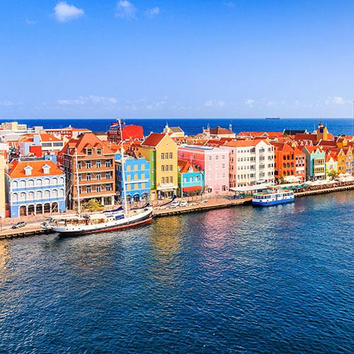
The Historic Area of Willemstad
The Historic Area of Willemstad, the historic capital of Curacao is a series of 17th-century Dutch houses that line the harbor and a unique pontoon bridge that opens and closes to allow ships to pass through. The site is a unique example of a colonial trading and administrative settlement, established by the Dutch, it began with the construction of Fort Amsterdam in 1634 on the eastern bank of Sint Anna Bay. Designated as a UNESCO World Heritage Site in 1997, the designation includes the historic city center and the harbor. The historic city and harbor is an outstanding example of European colonial history in the Caribbean, it combines Dutch town planning and architectural traditions with local influences. Most of the original urban structure and architecture still stands today and dates back to the period between 1650 - 1900. The inner city of Willemstad consists of four distinct historic districts that reflect different eras of colonial town planning and development. Punda is the oldest part of the city, built in the 17th century adjacent to Fort Amsterdam, the only part of the city that had a defense system consisting of walls and ramparts, the other three districts; Piertermaai, Otrobanda, and Scharloo date from the 18th and 19th centuries. The first buildings here were designed in traditional Dutch brick style, where the so-called Curacao Baroque architecture evolved from in the 18th century.